Tuesday, April 29, 2008

Maneuver Practice

Flight #: 062-066
CFI: Kristie H.
Aircraft: Robinson R22 Beta II
Aircraft ID: Various

Past 5 flights have all been maneuver practice... just honing the razors edge. The final result of it all:
  • my normal approaches are rock solid - landing withing 3ft of desired point
  • autorotations are passable, not perfect, but passable. I still need to work on my entry speeds... I keep slowing down without trying.
  • air-taxi / quick stop - perfect.
  • hover autorotations - damn fine. I've learned to roll off the throttle S L O W L Y, and all else is smooth.
  • running landings - passable, need to work on my speed control here.
  • running takeoff - perfect.
  • max performance takeoff - perfect.
Feelin' good... feelin' really good.


Thursday, April 17, 2008

Slopes... my new thing.

Flight #: 061
CFI: Kristie H.
Aircraft: Robinson R22 Beta II
Aircraft ID: N8361N
Duration: 1.3hrs
Cumulative Time: 70.4hrs

Lots of practice again today. Focus on slope landings.

Here is how a slope landing is done:

Position the helicopter across the slope at a stabilized hover headed into the wind over the spot of intended landing (Frame 1). Downward pressure on the collective starts the helicopter descending. As the upslope skid or wheel touches the ground, hesitate momentarily in a level attitude, then apply lateral cyclic in the direction of the slope (Frame 2). This holds the skid against the slope while you continue lowering the downslope skid with the collective. As you lower collective, continue to move the cyclic towards the slope to maintain a fixed position (Frame 3). The slope must be shallow enough so you can hold the helicopter against it with the cyclic during the entire landing. A slope of 15 degrees is considered maximum for normal operation of most helicopters, However check the POH of the particular helicopter being flown for the manufacturer's recommended limitation.

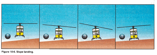
You should be aware of any abnormal vibration or mast bumping, that signals maximum cyclic deflection. If this occurs, abandon the landing because the slope is too steep. In most helicopters with a counterclockwise rotor system, landings can be made on steeper slopes when you are holding the cyclic to the right. When landing on slopes using left cyclic, some cyclic input must be used to overcome translating tendancy. If wind is not a factor, you should consider the drifting tendancy when determining landing direction.

After the downslope skid is on the surface, reduce the collective to the full down position, and neutralize the cyclic and pedals (Frame 4). Normal operating RPM should be maintained until the full weight of the helicopter is on the landing gear. This ensures adequate RPM for immeadiate takeoff in case the helicopter starts sliding down the slope. Use antitorque pedals as necessary throughout the landing for heading control. Before reducing RPM, move the cyclic as necessary to check that the helicopter is firmly on the ground.


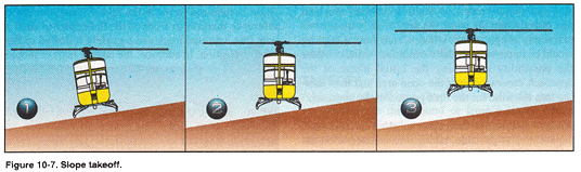
And a slope pickup is done:

Begin the takeoff by increasing RPM to the normal range with the collective full down. Then, move the cyclic towards the slope (Frame 1). Holding cyclic towards the slope causes the downslope skid or wheel to rise as you slowly raise the collective (Frame 2). as the skid or wheel comes up, move the cyclic towards the neutral position. If properly coordinated, the helicopter should attain a level atttude as the cyclic reaches the neutral position. At the same time, use antitorque pedal pressure to maintain heading and throttle to maintain RPM. With the helicopter level and cyclic centered, pause momentarily to verify everything is correct, and then gradually raise the collective to complete the liftoff (Frame 3).

After reaching a hover, take care not to avoid hitting the ground with the tail rotor. If an upslope wind exists, excute a crosswind takeoff and then make a turn into the wind after clearing the ground with the tail rotor.

Simple, huh. :)

Wednesday, April 16, 2008

More practice...

Flight #: 060
CFI: Kristie H.
Aircraft: Robinson R22 Beta II
Aircraft ID: N2356T
Duration: 1.0hrs
Cumulative Time: 69.1hrs

Some real crap weather the past few days. Finally got a chance to go up and really was in the groove. Getting better on my autorotations. Turns out that I'm very focused on the airspeed indicator and not paying enough attention to my attitude on entry. As such, I miss the sweet spot and end up spending my time chasing it.

Practice, practice, practice.

Thursday, April 10, 2008

Practice maneuvers before the checkride.

Flight #: 059
CFI: Kristie H.
Aircraft: Robinson R22 Beta II
Aircraft ID: N2356T
Duration: 1.4hrs
Cumulative Time: 68.1hrs

Now that I'm all done the solos, it is time to hone my maneuvers to a razor's edge. How does one do that? Well, first of all, you fly with Kristie. Every time I do something well, she resets my zero-point and won't let me continue until I repeat the maneuver and do a little better than last time. It's good... but what a hard ass! :)

Approaches are getting a lot better, and I'm really focusing on getting my autorotations down solid.

Sunday, April 6, 2008

Might as well just threw my money in the toilet!

Flight #: 058
Aircraft: Robinson R22 Beta II
Aircraft ID: N8361N
Duration: 0.3hrs
As PIC: 0.3hrs
Cumulative Time: 66.7hrs

LAME!

I had to get my .3hrs today... which consisted of pre-flight, run-up, sitting on the ramp for 4 minutes, run-down, post-flight. Did not even get to hover.

Ugh, what a waste of time. I should have just sat at the center tie down yesterday and let the rotor spin for a few more minutes.

Saturday, April 5, 2008

Last ramp solo... not.

Flight #: 057
Aircraft: Robinson R22 Beta II
Aircraft ID: N2356T
Duration: 0.9hrs
As PIC: 0.9hrs
Cumulative Time: 66.4hrs

Certification for the Private Pilot license requires 5.0 hours of solo time. Today's plan was to knock out the remaining 1.2 hours of solo time in Charlie pattern. Just so happened that Kristie was flying with another student in Charlie at the same time. Keeping an eye on me.

Weather was a bit iffy at the start... not pleasant, but definitely within my solo limitations. Did 4 pattern circuits and had a bit of a haze blow in. Not bad, but certainly not what I would call fun. Figured I would set it down on the taxiway and check weather to see if anything had changed.

I flipped frequencies. (which I learned is not something you are supposed to do... if the weather changes, the tower will come on and announce it to all. Never switch frequencies while in the airspace without permission to do so.) Weather sounded fine, and I assumed that it was a local / temporary thing and that it would blow by.

When I flipped back to Tower frequency, 119.3, I heard Kristie's voice:

Kristie: "...45 to talk with the student in 56-Tango."
Tower: "Frequency change approved."

Whoops, clearly Kristie is trying to reach me about something. I glance over, and see Kristie and her student hovering in the grass in my line of site while I'm sitting on the taxiway. I tried to flip over to a few common frequencies, but could not get her. (She was on 123.45, but I must have missed her.) I then asked the tower if they caught the frequency change, and they did not. At that point, Kristie and her student took off for another pattern, so it must not have been anything significant.

I looked into the pattern, and weather was fine... whatever it was had blown through and all looked good. I made my pattern and came in for a nice normal approach. Again, all well, so headed back up again. And there it was... fog/mist/haze/rain. At that point, I decided to head back... not going to chance things if I can't see 100%.

I requested clearance to get back to the center tie down, and set down. Spun down the helicopter and checked my Hobbs timer. 0.9hrs! All I needed was .3hrs more. Ugh. It takes, minimum, .1hrs to warm up and .1hrs to cool down the helicopter. (.1hrs = 6 minutes, BTW). That means I would have just enough time to lift off the ramp, back up, go to the hover cone and request clearance for Charlie. By that time, I'd have to come back and land again. Ugh. What a pain in the ass.

As a bit of a side note... as soon as everyone heard Kristie asking to talk to her student on another "private" frequency... they all switched over to hear me get yelled at, or something. Turns out, all she wanted to do is to tell me that if I wanted to continue this another time, then I should just head back early and we'll pick it up later. Apparently she also tried to text me on my phone... but I can't really get to that while I'm flying, so that was lost.

So, fine flight, although I've got to waste .3hrs tomorrow to get to my minimum.

Thursday, April 3, 2008

I own the night...

Flight #: 56
CFI: Kristie H.
Aircraft: Robinson R22 Beta II
Aircraft ID: N2223P
Duration: 3.0hrs Night
Cumulative Time: 65.5.hrs

Last night was my first real night flight. Kristie actually took me out for a night-ish run into Portland as a "tour". But, I was really a passenger only, as that was my 2nd flight.

This was all me, and it was breathtaking. No other word for the experience. Not only am I flying a helicopter... I'm flying it at night, and looking at some fantastic scenery at the same time. Kristie had mentioned that night flying was cool, and the navigation was pretty simple when over populated areas... "you just follow roads".

And she was right. The image above is not mine, and it is not from this flight - it was just ripped from the web, but this is exactly what it looked like. Roads are very visible from the air. Street lights, yes... but the car lights are perfect. Red, they are going away from you. White, headed your direction. Kind of obvious, but it lets you know exactly what side of the road you are on.

Towns show up as pretty well defined clusters of light. Airports and other aircraft are very visible. Just a great experience.

There were three distinct parts to this journey:

Part 1: South - Hillsboro (KHIO) to Albany, OR (S12)
We left Hillsboro at 8:13pm (end of civil twilight), which when a night flight officially can start. Wind was calm and traffic was pretty light. We headed north to Rt. 26 and followed that East. I had completed a flight plan, and that had me flying all the way east to I-5, which we would then follow south to Albany, but, as we crossed 217 South Kristie diverted me down 217. Not a problem, they both meet up, and I knew that.

It was incredibly cool to follow the traffic like that. Roads were very visible and it was obvious where we were headed. I had chose to fly at 1500ft for the trip, mainly cause I thought it would have been easier to see features, lights, etc... but I could have been at 5000ft and not missed a thing. I stuck to 1500ft anyway. It was amazing what I could see... a few cops busting people for speeding, etc. No wonder they use aircraft to catch speeders... EASY, and and they never know you are there.

Radio communication as perfect this flight for me... no flubs at all.

As we passed Aurora (KUAO) we got to try out the pilot activated lighting system. This is feature of may airports that allows the pilot to tune to the common traffic frequency and then turn on/off/up/down the runway lights. All you have to do is to toggle your mic on/off.

3 clicks in 5 seconds = Lights on Low
5 clicks in 5 seconds = Lights on Medium
7 clicks in 5 seconds = Lights on High

It is pretty cool to flying along and then click you mic 7 times and have a runway appear out of nowhere. Chasing "rabbit" lights and all.

Did a few patterns on Albany on the way in. Night certainly messes with your depth perception, I came in too high for two approaches. Finally figured it out, but took me two go-arounds.


View Larger Map

Part 2: Refueling in Albany, OR (S12)

Don't know why I thought this was so cool, but I do. Self service helicopter refueling. Albany, shown here, has their own self-service fuel service.

You just follow the blue signs that say "Fuel" and land in front of the pump, shut down and head on over with your credit card.

It asks you to first ground the helicopter, then to verify the fuel type. Once you verify this, you enter the # of gallons you want, and you
are off to the races. Pretty much the same as a standard gas pump, except you have a 75 foot hose to use.

When you are done with the fill-up, you press a button to retract the heavy spool of hose, hang up the nozzle, and then unhook the grounding wire. That's it. Simple, fast... and fun.


Part 3: North - Albany, OR (S12) to Portland Downtown Heliport (61J) to Hillsboro (KHIO)

The flight back was pretty uneventful. Straight and level for most of the flight, until we got to the edge of downtown Portland. You need a 3 hour night flight for your certification, and we would have made it back in about 2.6hrs... so Kristie diverted me to the downtown heliport. Flying over the city at night is about 50x more impressive than flying over towns. Plus Portland has the river and 5 bridges to look at.

The approach to the heliport is a little tricky as it is located on the roof of a paring garage. So, it's not like you have 2000ft to pick your spot. You have a 50ft circle you need to land in.

I came in too high... surprise, and we did a go around. It is a little different in downtown Portland, since you don't want to be over the river, and you want to avoid buildings and cranes. So, it took a little distance for us to get in the right setup again. But, I did, and we landed nicely.

Takeoff was also different. Kind of feels like you are jumping off a cliff... the heliport disappears from underneath you after about 2 seconds. So, we did a max-performance takeoff and headed back to Hillsboro.

Ride back was quiet and simple. Straight in to runway 20, and hover taxi over Alpha taxiway to parking. Very quiet at the airport... nobody home. We were the only ones there. It was 11:20 after all.


View Larger Map


Night flying is absolutely amazing. Coolest thing I've done in a helicopter to date.

Have to knock out another 1.2 hrs of ramp-solo flying soon. That is going to be boring after all the cool stuff in the past few flights.

Wednesday, April 2, 2008

X/C Solo - Total Success!

Flight #: 055
Aircraft: Robinson R22 Beta II
Aircraft ID: N7526S
Duration: 1.4hrs
As PIC: 1.4hrs
Cumulative Time: 62.5hrs

Well, I did it. A fantastic solo cross country flight in the "Triangle of Death". Since I was not with Kristie for this, I typed up a debrief for her... so rather than re-typing it all... here it is.

From: Chris
Subject: X/C Solo - Triangle of Death
Date: April 2, 2008 10:58:10 PM PDT
To: Kristie

Kristie-

Wanted to give you the full details of the flight today. In general, it was a great flight, but I really did not have the time to tell you all the details - coming back so late and all and stepping on your next flight.

So, here are all the details:
  • Preflight. No issues, although I want to have you run me through the transponder in 7526S. It is different than the others and I want to make sure I know how to flip it over in case I need to squawk 7600. I'm sure I could muddle through it, but I did not want to screw around this time.
  • Lift off. No issues, all good.
  • Hover at cone. No issues, all good.
  • Takeoff. Glad we talked about this the other day, since it was the exact situation we discussed. Wind from the north and I wanted to head south. So, crossed 30, got to 700ft and then looped around to my heading once I was out of the airspace.
  • Return to HAI. It was exactly at this point where I noticed I had the old flight plan in my kneeboard, and the one you "cleared" was in my folder under the chair seat. So, got to be honest here, I really thought about flying on the old one as it really had all the details that I needed for the flight. Stupid mistake, I know. But hey... I ended up doing the right thing. Actually, it was a good experience in and of itself. I contacted the tower and requested an approach to HAI. Immediately the controller asked "Is this a return back to the airport?". I said yes, and then a prompt, "Do you need any assistance?". That was kinda nice... since it was clear he was ready to help if there was an issue. I didn't tell him I was just a retard and forgot to take my new flightplan out from under my seat. Approach was normal, no issues at all on the way in. Thanks for checking in tho to make sure it was not a big deal.
  • Takeoff - Take 2. Same as before, same wind, same north departure.
  • 1st Leg. Stayed at pattern altitude for the 1-2 miles out, and then climbed up to 2000ft. As I crossed the ridge I flopped over to FSS and activated the flight plan. Dude was a little chatty, and I was not in the mood to have a conversation, but no issues. It was at this point where I realized I was clipping along at just under 90 knots. Man those things act differently when you are without a passenger.
  • Checkpoint: 5 & 205: Came in a little to the south, but was able to correct my angle a bit so that I crossed right over. I also switched over to Aurora's CTAF. Wow, it was busy. Took a few minutes before I could get a word in.
  • Checkpoint: River-bend crossing: I was keeping it between 80-90 knots for the whole flight. It was a little faster than on the flight plan, but then again, I did start a little late. I "last call"'d Aurora and checked weather one last time before switching over to Mulino CTAF.
  • Checkpoint: Mulino: Pretty busy here as well. No communication issues. Came in a little low to the pattern, 700ft, but decided not to correct since I was already on a nice approach. As I was entering the downwind a F/W was just landing on 32. I announced that I was coming in for a landing on Taxiway 32. As I turned final, the F/W was taxiing at me, so I corrected announced the change and corrected to the runway. Was a bit of the "race car swerve" you hassle me about, but I was not sure what else to do in that situation. Go around would have been an option, but since it was all clear I just went for it.
  • Hover Taxi @ Mulino: Rather gusty, actually, once I got down. I hovered over to the taxiway and set down to deal with the carb-heat and then immediately headed out on taxiway 32.
  • Checkpoint: Aurora: It was insanely busy, as you had mentioned. Lots of traffic, and chatter, but it was rather organized actually. Crossed midfield at 2000, no issues.
  • Checkpoint: St. Paul: Switched over to McMinneville and quickly heard that this was going to be the craziest part of the whole flight. People were being idiots. A number of people were making approaches to Runway 35. I heard someone ask about the active runway, and it was clear that it was Runway 4. Someone, not sure who, but someone with a very authoritative sounding voice went in to a rather long discussion about why runway 35 was not being used and that 4 was the active. Literally seconds after the woman stopped talking, some F/W said they were turning final for 35. Christ.
  • Checkpoint: McMinneville: I did as we did before, got to 700 ft as soon as I could see the airport. Announced and crossed the extended centerline of runway 22. Still people were bickering about which runway to use. Some dude finally came on and said "I assume everyone understands that 4 is the active and not 35 and will be correcting their patterns so that we don't have two intersecting active runways." At this point I was about to enter the downwind for 4 and just let the rest of the world know. It is really clear when you hear HAI students and CFIs on the radio... they all speak the same way. Kind of nice where you here some dude "taking off on the runway". I came in for a hover, and since I was not in carb-heat yellow, just took right off again without a set down, knowing that time was tight.
  • Checkpoint: Newberg VOR: Headed off for the VOR, way off to the west. Spotted Chehalem's barn right away... thanks for that trick. Flubbed my call here. Reported East and not South West. But, caught it right away and corrected. It was about here where I realized that I was never going to make it back on time and tried to call base on 122.85. I guess i was out of range, cause my first two calls did not get answered, so I just figured I was either doing it completely wrong and needed a different frequency, or had to wait till I crossed the ridge. As I was checking weather at HIO, I looked over the flight plan to see if there was any notation on this situation. Nope. Soon as I crossed the ridge I tried it again, and got DC. So, must have been in the radio-shadow of the ridge.
  • Checkpoint: Twin Oaks: Spent some time talking to Twin Oaks, while being far off to the west. No issues, all good.
  • Checkpoint; Goal Posts: As soon as I was abeam Twin Oaks, and there was not traffic on the radio / in sight, I did as you suggested and got on to HIO's Tower. Announced when I was 6 miles out... just to be safe. Hit the goal posts, dead on this time... knowing that I had to correct west a bit, followed the road up to the church.
  • Approach: All good, no issues here.
  • Landing: A tad skewed on the set-down, but did not bother to correct. Purely a rushed choice here. Only a few degrees, not awful; would have corrected if I had more time.
So, a pretty good flight in my mind. Felt a bit rushed... cause I was. Felt a bit stupid about the return to base thing, but really did not want to fly with the wrong flight plan. Plus I know I would have gotten hit if I tried it with you there. Surprisingly, it was not stressful at all. We'd done this a few times, and I felt pretty confident. Once I got past the forgotten flight plan, which I corrected, there was nothing else to be concerned about.

That's it... did I miss anything you want to hear about?

See you tomorrow for the night flight... 730pm. I'll have both flight plans ready and filed.

Later,

-c

Looking forward to the night flight. HIO to Albany, OR (S12)


Tuesday, April 1, 2008

Pre-Solo TOD

Flight #: 054
CFI: Kristie H.
Aircraft: Robinson R22 Beta II
Aircraft ID: N2223P
Duration: 1.5hrs
Cumulative Time: 61.10hrs

Weather has been total crap for the last week. Hailstorms, almost daily. When it was not hailing, it was 25 knot winds. Of course, all this was with 500ft cloud ceilings too.

So, as you might guess, not a flight.

Today, however, was perfect. 50ยบ, sunny, with calm winds. Perfect for my pre-solo "Triangle of Death" flight. Pretty uneventful flight, actually... but that is a good thing. Only issues were that I had the wrong frequencies in... twice. Stupid stuff that I caught as soon as I did not hear anybody on the channel... but still. 135.65 when it should have been 135.67, and 129.09 instead of 129.9. Just need to double, triple, quadruple check myself.

Oh, and apparently the common "report 1 mile south" reporting point used by the tower is not actually 1 mile south. I was about 2 miles south of that point and said "3 miles south" when giving my current position... and was promptly corrected that I was actually 4 miles south. Huh?


Here is how it all works. Portland Hillsboro Airport is a Class D airspace, which means there is a 3D cylindrical solid, centered on the tower, with a 4 mile radius, extending from ground level to 2500ft above ground. In this case, the airport is at 208ft sea level... so therefore it actually extends from ground level to 2700ft. Before you enter Class D airspace, you have to let them know you are coming... and what I told them was that I was already inside their airspace. Not cool. The sectional map shows it like this:


Obviously a map does not represent the real world perfectly... so if we were to draw the same airspace on a satellite map you would see something like this.


Anyway, the point here is, the 2 mile ring actually touches on something all the pilots and CFIs call "The Goal Posts".
The goal posts are two cell towers that act as a great visual reference for your way back home from the south. From up close, they look like... well, goal posts. You can click on the image for a larger view, but they are there. And, they are pretty easy to see from a few miles out.

So, as you are headed north, back to HIO, you thread the goal posts and head straight in to the airport. You just follow the road in at 700ft and you will come right in line for an approach to the ramp. Nice and easy. Just like this:
All seems pretty easy, except that they call the goal posts, "1 Mile South". So, I reported where I was in reference to those goal posts... I was telling them that I was already in their airspace. Turns out, while I was reporting my position incorrectly, I was actually not violating their airspace at all... I was actually just on the edge.
See, the "1 Mile South" point is actually 2 miles south.

You learn something new every day. I suppose I should have picked up on this already. Nothing like a mistake to get you focused on getting it right next time.

So, all in all, fantastic flight. The proof? Kristie cleared me for my Solo Cross Country!

Hoping for nice weather tomorrow.